
Iran rejects claim over Strait of Hormuz, responds with satirical map
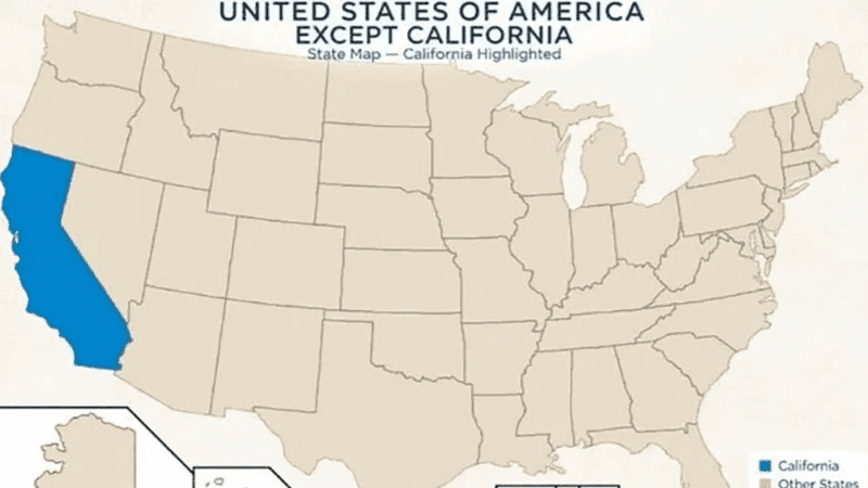

Iran has published a satirical map in response to US President Donald Trump’s statement declaring the Strait of Hormuz part of the United States. The map, posted on the social media account of Iran’s consulate in Hyderabad, India, depicts California as the “new territory of the Islamic Republic of Iran”.
The satirical map is believed to have been released to highlight the hollowness of Trump’s unilateral claim over an international territory.
Earlier, while speaking at an event at a police academy in New York, Trump claimed that Iran was losing disastrously. He also remarked that once Iran was completely defeated, the Strait of Hormuz would quickly be declared part of the United States. Asserting that Hormuz had already become part of the US due to the American naval blockade, Trump said no ship would be able to pass through that route unless Washington allowed it.
Tehran has directly rejected Trump’s claim. Iranian Deputy Foreign Minister Kazem Gharibabadi said it is not possible to seize the Strait of Hormuz merely by posting on social media, sending aircraft carriers or issuing a unilateral order. In his words, the Strait of Hormuz belonged to Iran, belongs to Iran and will always remain Iran’s.
Gharibabadi further said that just as Trump has correctly written the name “Persian Gulf”, his misconception about the Strait of Hormuz will also be corrected soon.
Following Trump’s statement, questions have also been raised about the possibility of establishing US sovereignty over the Strait of Hormuz under international law. An Al Jazeera explanation stated that the sovereignty of a territory does not change through a unilateral declaration by a head of state.
According to US constitutional expert Bruce Fein, a president cannot unilaterally incorporate any region as part of the United States. Such a step requires a treaty approved by the Senate or a special law.
International law expert Natalie Klein noted that to establish US control over the Strait of Hormuz, military force would have to be used to occupy Iran or its coastal areas. Such a situation could be comparable to US military rule in Japan after the Second World War.
Under the United Nations Convention on the Law of the Sea, the territorial waters of a coastal state can extend up to a maximum of 12 nautical miles. The narrowest part of the Strait of Hormuz is about 21 nautical miles wide. As a result, the 12-nautical-mile territorial waters of Iran and Oman come close to each other there.
Neither the United States nor Iran is a party to the Convention on the Law of the Sea. However, many principles related to international waterways such as straits are considered established and recognised rules of international law.
Iran’s satirical response came immediately after Trump’s threat to declare the Strait of Hormuz part of the United States. The map published on the social media account of Iran’s consulate in Hyderabad identified California in the United States as Iran’s “new territory”.
Leave A Comment